
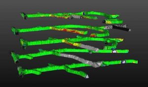
Visualization of laser scanning results from a stoping mine
The benefits of using laser scans for recognising ground movements has been long known. Until recently this has been a cumbersome and time consuming task. BE is now able to offer a quick and accurate method using portable laser scanning devices. The data captured between subsequent scans can be used for:
- Indicating compromised ground support
- Highlighting areas for rehabilitation
- Ground support system effectiveness
- Assisting to calibrate material properties for numerical simulations
- Assisting the recognition of rock mass instabilities
We are able to assist your site with options to rent or buy the laser devices. We are also able to deliver the required training on how to conduct the scans, process the data and get the most out of this emerging technology.
For more information download a paper on “The use of three-dimensional laser scanning for deformation monitoring in underground mines.”
Or, for more details contact David Beck, dbeck@beck.engineering.

Example image of deformation mapping data from an example mine showing regions of localize deformation at a drive.

Example image of deformation mapping data from an example mine showing bulking in shoulders and backs (left) and large deformation in walls of a drive (right)